Two standing stones near the village of Baltray overlook the Irish Sea and the Boyne Estuary. In 1999, three Drogheda men discovered a winter solstice sunrise alignment at the stones. At dawn in prehistory, the sun would have risen out of the sea behind the Rockabill islands off the Irish coast. This alignment might be recorded in local folklore.
There are two standing stones at Baltray, a coastal village located at the mouth of the River Boyne, a place known in ancient mythology as Inbher Colptha (also Inber Colpa). The stones are situated on the edge of a ridge, overlooking a raised beach towards the sea to the east. There were originally three stones at the site, but now only two are visible. The stones are slabs of shale, set 9 metres apart. Significant astronomical and mythologyical discoveries have been made by Mythical Ireland at Baltray. The first chapter of our book Island of the Setting Sun is devoted to Baltray and its significance to the wider astronomical landscape.
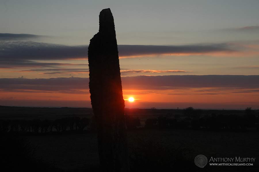
Winter solstice sunrise 2000

The glorious moment of sunrise over the sea is a captivating event. But this fantastic natural phenomena takes on a different meaning at the time of winter solstice, especially at ancient sites where this solstice was marked in a special way by the Stone Age people.
At Baltray, on the east coast of Ireland and near the mouth of the famous Boyne River, there are two standing stones, one of which marks the solstice in a very unique way, linking up with the landscape in a union of heaven and earth which occurs just once every year.
The large stone points to Rockabill, two small islands out in the Irish Sea off the coast of Skerries, and located 15 miles from Baltray. In modern times the larger of the two islands has a lighthouse which is used to warn ships of the islands in the busy shipping channel which serves the port of Drogheda through the River Boyne, and also Dublin through the Liffey.

It is at Rockabill, on the shortest day of the year, that the sunrise occurs, rising in its most southerly azimuth for the whole year while "standing still" for five days. Because of an effect of wobble on the earth's axis, the rising position of the sun has changed slowly over time, and now the sunrise occurs two sunwidths (approximately one degree) to the left of Rockabill.
Archaeologists say that standing stones were erected from circa 2000BC onwards, with a more specific Later Bronze Age dating (c. 1400 - 700BC) for stone alignments (two or more standing stones), but the dating of stone alignments has been much debated. (Archaeological Survey of Co. Louth, Victor M. Buckley and P. David Sweetman.)
The Baltray stones are unique in Co. Louth, the location of many of the events and happenings in the epic Irish legend The Táin. because Baltray is the only existing alignment in the county. Two other stone alignments, bothat Carrickedmond, no longer exist. There are a total of forty single, or isolated, standing stones in Co. Louth.
Due to the often inclement Irish weather, the winter solstice sunrise and sunset can sometimes be difficult to see. In December 2000, around the time of the shortest day, the weather had been quite bad. We journeyed to Baltray on Tuesday December 19th, but the whole sky was overcast and we didn't see a sunrise. On Dec. 20th, it was raining heavily so that was another no-show.
There was better news on the day of the solstice itself (December 21st). At 7:30am, the thin waning crescent moon could be seen high in the sky, and by 8am it was obvious that most of the sky was free from cloud. However, there was some cloud lurking on the eastern horizon and this caused some problems, obscuring the sun for the first five minutes or so after sunrise, which occurs at 8:35am.
At Newgrange, where the sun normally penetrates the passage at 9:04am, there was a no-show, much to the disappointment of all those who turned up. But at Baltray, the sunrise was glorious, and the cloud which threatned to ruin the whole event actually made the sunrise more colourful.
Regrettably, the presence of a misty haze at sea prevented us from seeing the Rockabill islands during the sunrise, but the photograph below shows the Winter Solstice sunrise of 1999 captured by Michael Byrne on video, with the position of Rockabill arrowed.
A number of visitors to Baltray enjoyed the sunrise event, and there were visitors on other days too despite the bad weather.

Given the obvious astronomical importance of Baltray, and its unique geographical location, we have concluded since making the discovery in 1999 that the site was very important. Ancient mythology indicates an astronomical significance, and alignments with another site have proven intriguing. The stones also mark full moonrise around the time of summer solstice.
It is also important to remember that the standing stones are the first ancient monument encountered on the Boyne River, at the entrance to the Valley of the Kings. The stones would also have formed a marker for the border between the ancient provinces of Ulster and Leinster.
Winter solstice discovery
During a visit to the stones in 1999, it was discovered that the larger of the two stones was oriented towards an island out in the Irish Sea called Rockabill. This led to the revelation that the stone and Rockabill marked the position of sunrise on the Winter Solstice.
Report from the Drogheda Independent newspaper, December 1999
A STUNNING discovery linking the mid-winter solstice sunrise, Rockabill (an island off North County Dublin) and standing stones at Baltray, has been made by three local men. Journalist Anthony Murphy, along with Richard Moore, artist, and Michael Byrne, photographer, confirmed the discovery on Tuesday week last, December 21 – the Winter Solstice.

The revelation came during an ongoing astronomical, anthropological and archaeological investigation being carried out by the three men into the prehistoric sites around the Drogheda area. There are two standing stones at the site in Baltray. The larger, and southernmost of the stones is 2.9 metres high. It is a large, thin stone with flat sides.
During a visit to the stones in early July, Michael Byrne discovered that when he placed his binoculars against the flat side of the larger monolith, Rockabill was visible in the field of view. ‘It was as if the flat side of the rock was used as a ‘pointer’ towards Rockabill, said Anthony Murphy, who works as a journalist with the Drogheda Independent.
Working from an Ordinance Survey map, Mr. Murphy worked out that if he drew a line between the standing stones and Rockabill, the angle was approximately 129-130 degrees. ‘I knew that this was roughly the rising position of the sun at Winter Solstice, having done plenty of research on the mid-Winter spectacle at Newgrange,’ he said.
‘I consulted my computer software – a program called SkyGlobe, which incidentally was used to investigate alignment between one of the Giza pyramids and the star Sirius by author Robert Bauval – to work out the rising position of the mid-Winter Sun as viewed from this area, and the figure I came up with was approximately 130 degrees.’
‘So naturally we were anxious to see the actual Solstice sunrise at the stones to confirm our theory.’ ‘On the morning of the Solstice, it was decided that I would go and see the sunrise at Newgrange, while Michael and Richard were dispatched to Baltray to test my theory,’ Anthony explained.

At around 8.30 that morning, Richard Moore and Michael Byrne watched as the sun crept up over the Irish sea – and to their delight the globe of the Sun rose just slightly to the left of Rockabill – between one and a half to two sun diameters to the left, or East, of the island.
Michael Byrne shot a video of the event. ‘To say we were astonished with the revelation is an understatement,’ said Anthony, who has been an amateur astronomer for the past 17 years.
‘At Newgrange, the sun begins to rise at 8.58am - later than at Baltray because it has to rise over Donore hill – but the precise alignment with the passage at Newgrange has shifted over time, and the sun now rises about two sun diameters to the left of where it originally rose circa 3000BC.’
‘This is caused by a slight shift in the Earth’s axis, and means that the same situation applies to Baltray. Assuming that the stones are of megalithic origin, the alignment would have been perfect!’ ‘It is a very unusual alignment in that although two stones are used to mark the line of sunrise, one of these stones is an island way out in the Irish sea!’ ‘We will of course be carrying out further research into this phenomenon, which comes after further recent revelations about solar alignments at prehistoric sites.’
Local woman Anne Marie Moroney has recently published a book which shows how the setting sun at Winter solstice illuminates the southern passage at the Dowth mound in Brugh na Boinne.
Furthermore, the Winter issue of Archaeology Ireland magazine carries an article about a team of researchers in the West of Ireland who have found that a row of standing stones at Killadangan in County Mayo are aligned with the setting Sun on midwinter’s day.
‘We’re very excited about it, particularly because of the timing with the event at Newgrange being broadcast live on television, and also because the standing stones in Baltray are little known about, and mark the first prehistoric site encountered along the Boyne River.’
The men are planning to release a book some time next year detailing the results of their research in this area. ‘We are basically looking at the broad picture,’ said Richard Moore, ‘and have established firm links between the ancient sites, legend and folklore, and astronomy.’
‘Taken together, these three aspects make the whole thing very interesting, and our aim is to heighten awareness of the definite astronomical purpose which these people, and their monuments, had,’ Mr. Moore said.
‘We would like to say a word of thanks to the landowners who gave us kind permission to examine the stones,’ he concluded.
-Drogheda Independent
Summer sunset and moonrise
Because the large standing stone marked the position of Winter Solstice sunrise, it also marked the setting position of the sun on Summer Solstice. At certain times of the lunar cycle, the moon's rising position also coincides with that of the Winter Solstice sunrise. The moonrise was observed on July 17th, 2000 at Baltray.
A unique astronomical event occurred on the evening of June 17th, 2000, at the Standing Stones in Baltray. With the Summer Solstice sunset occurring in the northwest, the full moon was rising in the southeast, quite close to the point of the Winter Solstice sunrise. The large stone at Baltray marks Winter sunrise and Summer sunset.
The Winter Solstice sun rises about 130-131 degrees in the southwest on December 21st. The moonrise on June 17th, 2000, was at 129.5 degrees of azimuth, quite close to the winter sunrise position, on which the large monolith at Baltray is aligned. The island of Rockabill, on which is built a lighthouse, forms the other end of the alignment.
Unfortunately on this occasion there was some cloud on the eastern horizon despite generally clear skies overhead. This meant we could not record the actual rising position of the moon, but as can be seen from the above picture, the moon's position is nearly coincidental with that of the winter sunrise. For this photo I was positioned about 30 feet northwest of the large stone, so we are viewing it almost edge-on.

In this close-up photo of the event, the light of Rockabill lighthouse can be seen (arrowed), as can the moon which is rising out of the clouds. Although the Winter sunrise occurred originally at Rockabill as viewed from here, it now rises two sun-widths to the north, or left, of Rockabill because of the slow shift of precession. Nevertheless, the alignment of the standing stone on these astronomical events is still quite accurate.

In this photo the moon is beautifully framed by a cut-off in the top of the standing stone. Note also the lovely pale reflection of the moonlight on the surface of the sea.
We sought the opinion of a local archaeologist in putting a date on the erection of the Baltray standing stones. Although there is some debate as to whether standing stones were erected in the early or late Bronze Age, the archaeologist told us that a date of around 2000BC is generally accepted as the date of their construction.
Despite the initial cloud problems, it turned out to be a glorious event, with the veiled moon showing pink and orange colours behind the thin clouds. It was a very warm night, and even after the 10:30 (approx) moonrise, most of the seven people who were there to observe the event stayed until almost midnight.
Thanks go to Victor Reijs, of Geniet, who provided GPS data for our exact location on the night.
TECHNICAL INFORMATION:
Moonrise, June17th, 2000:
Local Information: Position (epoch of date): RA: 18h 33m 43.49s Dec: -22° 27' 12.3" Altitude: 00° 02' 07" Azimuth: 129° 16' 45" U2000: Chart 340, Vol 2 Rise: 22h 23m 01s Transit: 01h 30m 12s Set: 05h 29m 48s. Geocentric Information: Position (epoch of date): RA: 18h 31m 48.08s Dec: -21° 40' 24.7" Constellation: Sagittarius. Phase: 0.992 Diameter: 1766.03" Phase Angle: 10.5°. Elongation: 169.5°.
Astronomical mythology
During our research we stumbled upon an ancient story which was told in Skerries relating to Rockabill and the sun god, Balor. This story, we believe, recalls the Baltray-Rockabill solstice event and describes the sun's movement along the horizon until it gets to Rockabill, its furthest rising point.
A fascinating link with Fourknocks site
In July of 2000, we discovered a rather curious alignment of the Baltray stones which was to have a significant influence on our belief that the Baltray stones were an important astronomical device in prehistoric times.
The alignment was discovered almost by chance when I was standing with the two stones in line with each other, to see if they pointed to anything significant. I lined up the stones so that there was a narrow wedge between them - and right in that spot I could see a television mast, which I knew was on the ridge near Fourknocks. With the stones in that position, I could see that at the very eastern limb of the smaller standing stone, there was a mound with a tower on it on the Fourknocks ridge.

This "tower" mound is located on the same ridge as the mound of Fourknocks. It has a six-sided tower, known as a folly, located on its peak. But the mound itself is probably of ancient origin, and given its proximity to the nearby Fourknocks mounds, is probably Neolithic.
We examined what relationship the Baltray stones might have with this mound, and considered other alignments between sites which we knew of in doing so. For instance, the passage of Newgrange, which is oriented towards the position of sunrise on Winter Solstice, is also oriented to the mound of Fourknocks, even though the latter cannot be seen from the former.
On consulting a detailed Ordnance Survey Map of the area, we discovered that the "tower" mound shared an interesting position in relation to Rockabill, the island already strongly associated with Baltray through astronomy and mythology.
To our astonishment, we found that the "tower" mound was located precisely due west of Rockabill island, on an elevated site overlooking the sea. This meant that there was a possible, or probable, link between the two sites and the rising sun on the vernal and autumnal equinoxes.
It was an amazing moment of discovery which brought with it a whole series of questions about the ancient people, and a new avenue of research. We confirmed that the Irish Sea is indeed visible from the top of the tower mound, but modern buildings and a thicket of trees prevented us from seeing Rockabill directly from the site when we visited just days after making the alignment discovery at Baltray.
We could only conclude from the evidence at hand that the Baltray standing stones and the tower site near Fourknocks formed part of a complicated astronomical system, and that the ancient people who used it were able to pinpoint the exact days of Winter Solstice sunrise and also Equinoctial sunrise using the island of Rockabill as a natural landscape marker.
We did not, however, have an opportunity to observe sunrise on the Autumn Equinox from the tower site and will have to wait until March 2001 to see if the phenomenon can still be observed today.
In the video below, Anthony Murphy of Mythical Ireland and Ken Williams of Shadows and Stone discuss a total eclipse which should have been visible aligned with Rockabill, but it was cloudy:
20th anniversary
In summer 2019, Richard Moore, Michael Byrne and Anthony Murphy returned to the Baltray standing stones to celebrate the 20th anniversary of their discovery, and to get a photograph together at the stones, something that hadn't been done in 1999. Read more about this 20th anniversary gathering here:
