In 2018, a summer heatwave dried the land of the Boyne Valley in Ireland, revealing the shadows of previously unknown circular enclosures in the landscape surrounding the world-famous site of Newgrange. One of the most intriguing was the distinct outline of a large henge. It was found using a drone by Anthony Murphy, author, researcher and Mythical Ireland founder, who shared with Ancient Origins magazine the moment of discovery and just how significant it really is.
In July of last year, you and photographer Ken Williams made one of the most significant discoveries in archaeology for the year, if not the decade – traces of an enormous and previously unknown henge in the Newgrange landscape. Considering Newgrange is one of the most studied landmarks in Ireland, why wasn’t this henge known about before?
The answer to that is relatively straightforward. The henge was likely to have been constructed entirely of timber. It was unlike some of the other nearby Boyne henges which are embanked and are clearly visible in the landscape. The field in which the new henge is located has been ploughed continuously year after year for probably the last 70 years or so. So the top two feet of archaeology has been wiped away. But what lies beneath that is effectively hidden from view. Now there is some discussion among archaeologists about what happened to the soil from the double ditch sections which had to have been dug out. It might be that subtle surface traces of this that might have been visible in pre-ploughing days has disappeared. But I am speculating here.

The point is that the reason this henge has not been discovered previously is because it has no surface expression. Interestingly, a LiDAR survey carried out for the Boyne Valley Landscapes Project by the Irish national Strategic Archaeological Research (INSTAR) Programme a decade ago did discover the adjacent henge, site LP2. A very subtle rise (they called it a “low topographic profile site”) in the field there led them to investigate further. They suggested the feature is a denuded passage-tomb, with a henge around it. At the time, the INSTAR geophysics (magnetic gradiometry) survey was confined to that part of the field. The geophysics revealed the passage-tomb and henge. Ironically, the drone images of site LP2 taken by Ken Williams and I in July 2018 actually show more of LP2’s detail than the much more expensive gradiometry imagery!
Fascinatingly, the LiDAR imagery examined by the INSTAR project did reveal a feature at the location of our new henge, but something perhaps unexpected. They found a broad raised linear feature, with what might be a denuded mound at its western end. How this fits in with that lies beneath the surface remains to be seen. There has been some discussion about the possibility that the “mound” (it’s really nothing more than a very very subtle rise in the landscape) might in fact be associated with a box-like or “porch” feature on the northwestern side of our henge. Some of the post holes there are massive, and it may be that the earth was scarped up around whatever giant posts were in place there to support them. Again this is speculation. At some point in the future, archaeological digging may reveal more detail.
Having studied the INSTAR report (many times over!), I never would have thought there was a giant henge hidden beneath the surface there. It’s incredible. It took Ken Williams and I by surprise. But it took the archaeological community completely by surprise too.
What was that moment like when you were flying your drone over the area and spotted the henge for the first time? Did you realise straight away the significance of what you were seeing?
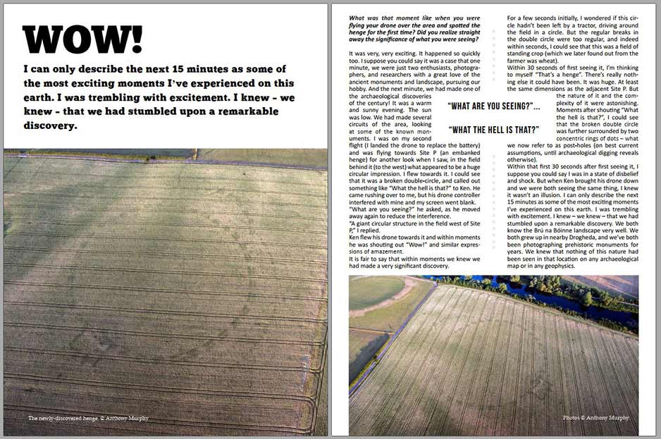
It was very, very exciting. It happened so quickly too. I suppose you could say it was a case that one minute, we were just two enthusiasts, photographers and researchers with a great love of the ancient monuments and landscape, pursuing our hobby. And the next minute, we had made one of the archaeological discoveries of the century! It was a warm and sunny evening. The sun was low. We had made several circuits of the area, looking at some of the known monuments. I was on my second flight (I landed the drone to replace the battery) and was flying towards Site P (an embanked henge) for another look when I saw, in the field behind it (to the west) what appeared to be a huge circular impression. I flew towards it. I could see that it was a broken double-circle, and called out something like “what the hell is that?” to Ken. He came rushing over to me, but his drone controller interfered with mine and my screen went blank.

“What are you seeing?” he asked, as he moved away again to reduce the interference.
“A giant circular structure in the field west of Site P,” I replied.
Ken flew his drone towards it and within moments he was shouting out “wow” and similar expressions of amazement.
It is fair to say that within moments we knew we had made a very significant discovery. For a few seconds initially, I wondered if this circle hadn’t been left by a tractor, driving around the field in a circle. But the regular breaks in the double circle were too regular, and indeed within seconds I could see that this was a field of standing crop (which we later found out from the farmer was wheat).
Within 30 seconds of first seeing it, I’m thinking to myself “that’s a henge”. There’s really nothing else it could have been. It was huge. At least the same dimensions as the adjacent Site P. But the nature of it and the complexity of it were astonishing. Moments after shouting “what the hell is that”, I could see that the broken double circle was further surrounded by two concentric rings of dots – what we now refer to as post-holes (on best current assumptions, until archaeological digging reveals otherwise).
Within that first 30 seconds after first seeing it, I suppose you could say I was in a state of disbelief and shock. But when Ken brought his drone down and we were both seeing the same thing, I knew it wasn’t an illusion. I can only describe the next 15 minutes as some of the most exciting moments I’ve experienced on this earth. I was trembling with excitement. I knew – we knew – that we had stumbled upon a remarkable discovery. We both know the Brú na Bóinne landscape very well. We both grew up in nearby Drogheda, and we’ve both been photographing prehistoric monuments for years. We knew that nothing of this nature had been seen in that location on any archaeological map or in any geophysics.

Your discovery prompted a detailed investigation by the National Monuments Service, which subsequently identified 22 archaeological monuments and features that were either previously unknown or only partially recorded. How has knowledge of the prehistoric landscape around Newgrange changed since your discovery?
Firstly, I should clarify something. Several of the archaeological features described in the National Monuments Service in its Interim Report (released on winter solstice 2018), were in fact discovered by Ken Williams and I during our aerial imaging of the fields around Newgrange on both the evening of discovery (July 10th 2018) and subsequent days. The report is very impressive, in that the archaeologists were able to use their considerable expertise to not only describe the monuments, but to suggest possibilities about what they were. Probably the most impressive of these 22 monuments and features – apart of course from the henge – is the so-called “Great Palisade”. This huge curving feature consists of a triple palisade, or fence, which would have been made of individual wooden posts arranged in a huge arc that extends for several hundred metres in a wide arc around the front of the ridge upon which Newgrange sits. There has been some speculation that this might be part of a “super-henge” or enclosure extending in a giant oval loop all the way around the ridge. If that transpires to be the case (and archaeologists will be studying these features for years into the future), this is a truly impressive construction.
In terms of how it changes our understanding of the Bend of the Boyne, it seems that the discovery of the henge and all the other features has been a seminal moment in our comprehension of the prehistoric landscape, and in particular the Neolithic features. Literature about Brú na Bóinne has tended – perhaps understandably – to focus on the great megalithic chambered cairns or passage-tombs of Newgrange, Knowth and Dowth. What we are seeing now is that these were just one aspect (albeit a very significant one) of a much more complex and impressive monumental complex. The monument complex wasn’t just concerned with death, and housing the dead. There are huge ritual spaces which likely encompassed significant gatherings and events, possibly associated with important calendar dates. The possibility must be considered that the Great Palisade served as a barrier of sorts between those ritual (and perhaps celebratory) spaces and the more sombre spaces of the passage-tombs, where the intimate and exclusive ceremonies around the bringing of the bones of the ancestors to the stone chambers took place.
Of great significance here is the population that must have been involved in ritual activity at Brú na Bóinne. For years there has been speculation and scholarly guesswork at the amount of people needed to build the great cairns. But when we account for the new henges (several were discovered last summer) and all the other features in the Bend of the Boyne complex, it becomes clear that this was a project – even if activity was spread over a few centuries – that was of such immense scale that it probably required a significantly greater population than could have been provided in the immediate area. The proximity of the new henges to the river Boyne lends credence to the possibility that there was a transitory population arriving and departing on boats – perhaps from other parts of Ireland and maybe even from further afield – to participate in the building work and indeed the ritual activity associated with these massive structures.
What’s your theory about how these henges may have been used? Does Irish mythology offer any clues as to their purpose?
That’s an interesting question, and one over which many experts have deliberated. I am personally interested in the work of Ronald Hicks of Ball State University in Muncie, Indiana, in this regard. Hicks has suggested that one great henge, known as Ireland’s Stonehenge, might have been part of an Oenach site. These Oenaige (that’s the Irish word in the plural) resembled “historical fairs, but with political and ritual overtones”. Hicks postulates that such large enclosures might have served as assembly sites, as suggested in mythology, some of which might have coincided with the end of the harvest at Lughnasa, or the beginning of winter or “dark half” of the year at Samhain. These oenaige are “not isolated monuments” but rather are parts of complexes that include other monuments of various sorts.

There is one intriguing reference in mythology associated with Newgrange (Síd in Broga) from which I have drawn a speculative but nevertheless interesting possibility – that the henges might, in addition to other functions, have been used as games or sporting arenas. The Boyne henges were clearly large, open-air monuments allowing for substantial gatherings of people. But what was the nature of these gatherings? Did they host elaborate ceremonies at certain times of the year, to commemorate certain festivals or feast days? Were they astronomically aligned, to allow for complex observations of the risings and settings of sun, moon and stars, as suggested in the folklore about Ireland's Stonehenge? Were they used for ritual sacrifices, such as those believed to have taken place at Pömmelte in Germany?
In Tochmarc Étaín (The Wooing of Étaín), an ancient story preserved in the 12th century Book of the Dun Cow, Dagda, the chief of the ancient deities the Tuatha Dé Danann, who built Newgrange, encourages his son Oengus Óg to go there and to take possession of it from its owner, Elcmar:
Elcmar will be at Cnocc Síde in the Bruig with no weapon but a fork of white hazel in his hand; he will be wearing a cloak with a gold brooch in it, and he will be watching the three fifties of youths at play on the playing field.

Where might this "playing field" be located? The Bend of the Boyne is a natural amphitheatre. Newgrange sits on the crest of a ridge allowing panoramic views of the area. An observer, such as Elcmar, standing on the top of Síd in Broga (Newgrange) would, in the Neolithic, have a sweeping view over a spectacular complex of huge and diverse monuments. A series of seven henges would be visible from the great passage-tomb, including the one we discovered which has become known as 'Dronehenge'. If there were sporting activities involving 150 people, certainly one can imagine the giant henges as suitable playing fields.
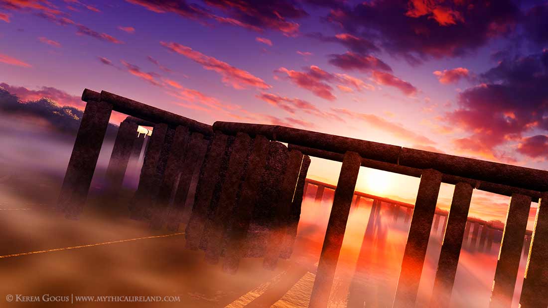
You have recently commissioned the 3D computerized reconstruction of what the henge originally looked like. How much of this process was interpretative, and how much of it reflects known features and materials of the prehistoric henge?
The 3D reconstructions are conceptual, based loosely around what we can speculate about the features as they presented in the drone imagery. We are dealing with a best-guess scenario combined with the opinions of archaeologists as to what the markings in the drone images might represent. There seems little dispute about the idea that the two outer rings of “dots” or “holes” probably supported large upright timbers. This was certainly the case at a much smaller timber circle at Knowth. But there are many questions. How tall were these posts? Were they free-standing? Did they support something else, a bigger structure? Were they designed to act as a barrier of sorts, a demarcation between the sacred space and that which lay outside it?

The double ring of segmented ditch features are just that, we are told – elongated holes in the ground. The reconstruction carried out by Kerem Gogus is based partly on other models that have been produced of henge or timber enclosure sites, but it is all we can hope to show for now, unless more conclusive evidence of the nature of the construction turns up during future archaeological digging. One of the greatest differences between a timber henge and a passage-tomb is that the latter is made from stone, while the former is made from wood, which is a perishable material that rots and vanishes with time. What we are left with are marks in the ground. We might never know the true nature of these timber henges.

The reconstruction shows a series of dug out ditches. What purpose would they have served?
My own knowledge on this subject is extremely limited. What I can tell you is that the double segmented ditch features are not just highly unusual – they are entirely unique for any known Irish henge. This is one of many aspects of Dronehenge that make it utterly fascinating. Archaeologists say that the segments are dug-out features, and that the gaps or spaces between them are the parts that were not dug out. In this respect, Dronehenge somewhat resembles a causewayed enclosure. What purpose did those ditch sections serve? I honestly do not know.

Your discovery suggests that drone technology has serious potential for the field of archaeology and could drastically change how research is conducted in the future. How much of ancient Ireland do you believe is yet to be discovered? Do you think drones will become essential tech in every archaeologist’s toolkit?
Ireland is a mosaic of archaeology. You cannot walk across Ireland without being more than a couple of hundred metres from some archaeological monument or remnant of the past. A huge amount of our archaeology has been damaged or destroyed by agricultural activity, especially since the introduction of mechanised agriculture. Tillage activity, particularly in the eastern portion of Ireland, has wiped away many monuments from the surface, but thankfully the plough only goes down into the soil by about two feet (0.6m), so many of the archaeological features or remnants of these monuments still exist beneath the surface. Drones, which are a very new technology, will almost certainly become a mainstay in the archaeologist’s toolbox. Aerial surveying is becoming a hugely important aspect of archaeological research. The drought of 2018 provided a once-in-a-generation opportunity to discover previously unknown monuments and archaeology beneath the surface. Sadly though, the Irish State is not sufficiently equipped or funded to provide ongoing aerial monitoring. Many of the monuments discovered during last year’s drought were found by amateurs flying drones. The publicity around our discovery of Dronehenge resulted in a huge number of discoveries around the country as drone owners and photographers took to the skies after seeing what we had found.
Even now, in 2019, I am using Google Earth to discover previously unrecorded monuments. Google Earth updated its imagery for eastern Ireland with satellite photos taken during the 2018 drought. So far, I have found 100 unrecorded monuments or archaeological features, which I have reported to the National Monuments Service here.
The last time we had conditions like this was in 1976 – long before drones existed and when aerial surveying for archaeological purposes was an expensive, exclusive and underfunded affair. Even today there is no ongoing monitoring, so amateurs will still have a significant role to play in the discovery and recording of archaeology in Ireland. And drones will undoubtedly be a critical aid in future discoveries.
Further reading
The new henge of Newgrange - a once-in-a-lifetime discovery.
The Newgrange henge: a preliminary investigation of possible astronomical alignment.
Three podcast interviews with Anthony Murphy about Dronehenge.
Further monuments found in drone footage from Ireland's Stonehenge.
National Monuments Service interim report into the discoveries at Newgrange.
The new henge of Newgrange: the moment of discovery recalled.
Dronehenge reimagined: 3D models of late Neolithic henge at Newgrange.