Loughcrew - Sliabh Na Calliagh
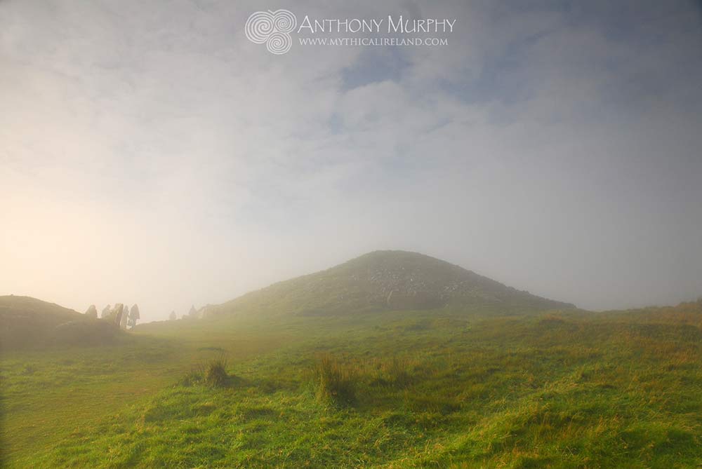
The Loughcrew cairns are located 40 kilometres from Newgrange, situated on three hill summits near the town of Oldcastle, Co. Meath. The hills, known collectively as Sliabh na Calliagh, or the Mountain of the Witch, are individually called Carnbane West, Carrigbrack (or Slieve Rua) Carnbane East (or Slieve na Calliagh) and Patrickstown. The highest of these peaks reaches over 900ft above sea level. The cairns are probably older than Newgrange, dating to between 3500 and 3300 BC, and many contain megalithic art and astronomical symbolism like that at Brú na Bóinne.
The cairns were explored in the 1860s, and described by archaeologist E.A. Conwell in a paper to the Royal Irish Academy in 1864. There were surveys and investigations carried on by Conwell, followed by Rotherham in 1895, and George Coffey at the turn of the 20th century. The cairns are probably older than those at Brú na Bóinne. Martin Brennan (The Stones of Time, P.151) says that "many of the symbols and arrangements used in Boyne Valley art were anticipated at Loughcrew".
Illuminated stones
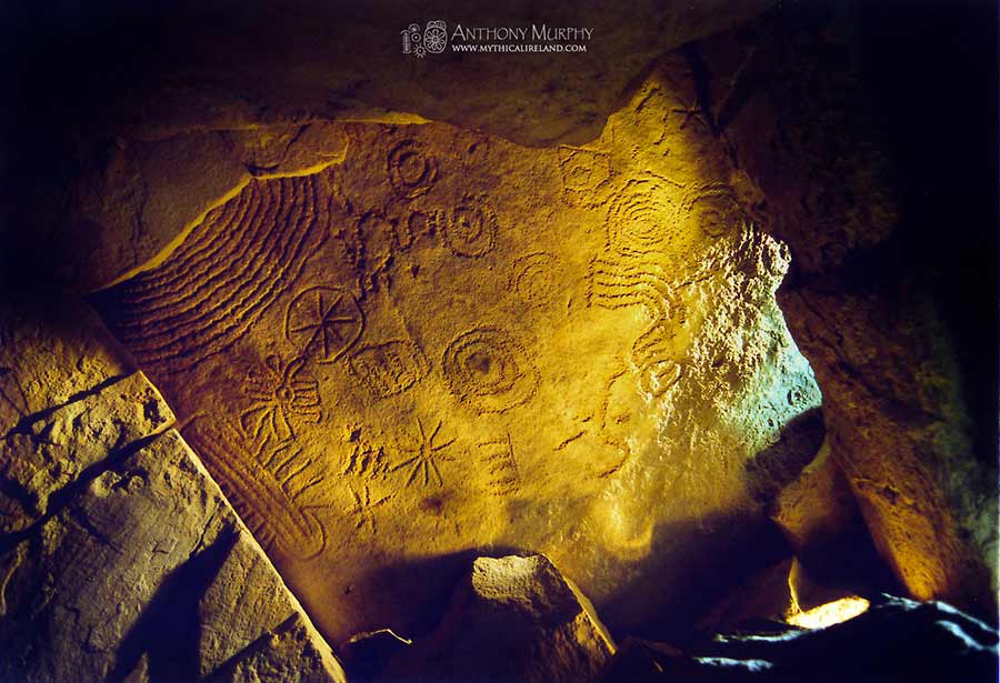
The wonderful ceiling stone of the end recess of Cairn T. The plethora of carvings give one the impression that the stone is supposed to serve as some kind of star map or astral guide. This stone is illuminated during sunrise at spring equinox. It is located directly above the 'Equinox Stone'.

The Equinox Stone with its wonderful markings. In Spring of 1980, Martin Brennan and Jack Roberts discovered that at dawn on the Spring Equinox, a sunbeam enters the chamber of Cairn T and strikes this stone, first illuminating the large sunwheel at top left before moving slowly down towards the large sunwheel to the centre right of the stone.
Brennan says: "The symbols on stone 14 may now be interpreted as the language of unknown archaic astronomers. The beam of light from the rising sun at equinox moves down the stone, illuminating key symbols as it progresses."
Stone 8 is just inside the chamber to the left of the passage looking out. The right edge of this stone, according to Brennan, models the projected beam of light in the chamber. The designs include concentric circles and arcs, a waved line (with a count of 9), a spiral, dots, grooves and other markings. In this photograph, we used small torches to 'paint' the stone, and bathe it in a lovely glowing light. This is the best way to accentuate the markings on the stones.
Cairn T holds a special significance in relation to Newgrange - it may have once been covered with milky white quartz, the same stone which was used on the facade at Newgrange. According to Jean McMann (Loughcrew - the Cairns), "until a few years ago, large pieces of quartz could be found behind the kerbstones and around the entry. Conwell also reported small lumps of quartz "strewn about" at the base of the Hag's Chair."
The main cairns are tumuli called Cairn L and Cairn T, although there are well over 30 sites remaining and, according to Martin Brennan (The Stones of Time), there may once have been as many as fifty to a hundred mounds.
Cairn L, on Carnbane West, is 45 yards in diameter, and has a passage 12 feet long. There are seven chambers within the passage interior. Conwell was reported to have found bone and pottery fragments in these chambers. A quadrangular stone basin, which has been hollowed out to a depth of over 3 inches, lies on the floor of one of these chambers. Stone basins have also been found at Newgrange, Dowth (North) and Knowth (East and West).
The truth about Ollamh Fodhla
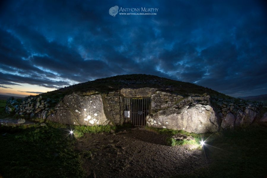
Cairn T, which is mistakenly known as the Tomb of the Ollamh Fodhla, is the most striking cairn on the hills. Ollamh Fodhla, said to have been the first law-giver of Ireland, died according to the Annals of the Four Masters in 1277 BC, and is stated to have been buried at Taillten (Telltown), which is an archaeological complex located some distance (c. 14 miles or 22km) from Loughcrew. There appears to have been no local tradition about the Ollamh being buried at Cairn T or Loughcrew until this idea was proposed by archaeologist Eugene Conwell in the 19th century. Writing in 1873, Conwell reaffirmed the view that Cairn T was the Ollamh's tomb, first proposed by another author, James Fergusson, who wrote in 1870 that the Loughcrew cairns must in fact have been the Taillten burial grounds. Conwell explicitly says that Fergusson was the first to propose this, and cast considerable doubt over the "wild legend" of the area that suggested, instead, that the passage-tombs of Loughcrew had been built by an ancient hag.
The wild legend that a witch had scattered these great heaps of stones out of her apron has been doing duty in this locality, from time immemorial, for the real name and history of the place; and probably would have continued for many a day longer to perpetuate the fanciful story, had not James Fergusson, Esq., &c., on 16th of August, 1870, carefully gone over the hills under our guidance. This practiced explorer, acute observer and clear-minded author has since published a large volume, entitled "Rude Stone Monuments in all Countries : their Age and Uses" – in our opinion the best written, and best arranged book ever published upon the subject of which it treats. In this profusely illustrated Work he has the honour of being the first to suggest, and he deserves the hearty thanks of every Irish Archaeologist for having done so, that these carns must be the remains of the cemetery of Taillten, this happy thought thus affording the means, we hope, of restoring a name and history to the great and forgotten "city of the dead" on the heights now called Loughcrew Hills.
Conwell, it seems, had given far too much credit and respect to Fergusson, who had literally disregarded the local myth, which had been perpetuated since "time immemorial", and instead replaced it with a myth which was foreign to the area. Similar attempts had been made at Brú na Bóinne, where it was suggested that the great monuments of Newgrange, Knowth and Dowth were, in fact, the burial tombs of the Tara kings. But nothing could have been further from the truth – especially because the construction of the great cairns of Brú na Bóinne and the reign of the kings were separated by three thousand years!
Unfortunately, Fergusson's wild claim about the Ollamh Fodhla, trumpeted so enthusiastically by Conwell, has entered popular modern belief, so much so that some visitors who come to Loughcrew do so in the fervent belief that Cairn T, or the Hag's Cairn to give it its proper title, is in fact the burial place of this mythical character who belongs to a much later period in prehistory, if indeed he ever existed! All of this is not helped by a popular belief in the British Israelite movement that the Ollamh is, in fact, the Biblical prophet and patriarch Jeremiah. Yes, there is a growing band of people who believe that, somehow, Jeremiah ended up being buried in Ireland. These are the same people who believe that the Ark of the Covenant is buried on the Hill of Tara.
The Hag's Cairn
Cairn T is 38 yards in diameter and has a kerb of 37 stones. The massive carved stone known as the "Hag's Chair" forms part of the kerb. It measures 10 feet by six feet by two feet, and the front face of the stone is highly ornamented with concentric circles, cup marks and other designs. The beam of spring equinox sunlight strikes the 'daisy' at top left and follows the zig-zags towards the next daisy-like feature.
Some of the stones at Cairn T were decorated before being put in place, as has happened at other sites such as Knowth and Newgrange. Gabriel Cooney (Landscapes of Neolithic Ireland) suggests that they could have possibly been used from an earlier site.
There is, according to Cooney, a preference at Loughcrew to orient the passages towards the east. But there is also a "deliberate alignment to other passage tombs, particularly Fourknocks to the southeast".

Cairn U
The highly decorated, but exposed, surface of stone 14 at Cairn U, beside Cairn T at the summit of Carnbane East at Loughcrew. Cairn U has a circumference of 48.2 metres, and the passage is oriented to 108 degrees (18 degrees south of east). A plan of the passage and chamber of Cairn U is shown above right. Its plan is similar to that of Cairn L.
Stone 8 is also impressive, but worn by the weather. The dot inside the circle, which is present in the centre of the concentric part-circles towards the top right of the stone, represents the sun, according to Brennan. This symbol for the sun persists to this day in astronomy. This cairn, like many of those at Loughcrew, appears not to have had a roof. The passage is extremely narrow, and its orientation does not seem to be toward any sunrise of calendrical significance, according to Jean McMann's measuremens, but some believe the passage to be oriented on Samhain and Imbolc sunrises (Nov/Feb Cross Quarter Day).
Cairn U back stoneBrennan says Cairn U "is synchronized with Cairn L to indicate the cross-quarter days on 8 November and 4 February, marking the beginning of winter and spring." Another small cairn, Cairn S, indicates cross-quarter days on 6 May and 8 August, marking the beginning of Summer and Autumn. Imagery on the back stone of Cairn U may represent the rising sun, according to Brennan.
Much of the art at Loughcrew is exposed to the elements, and thus is faded and difficult to see except under special lighting conditions.
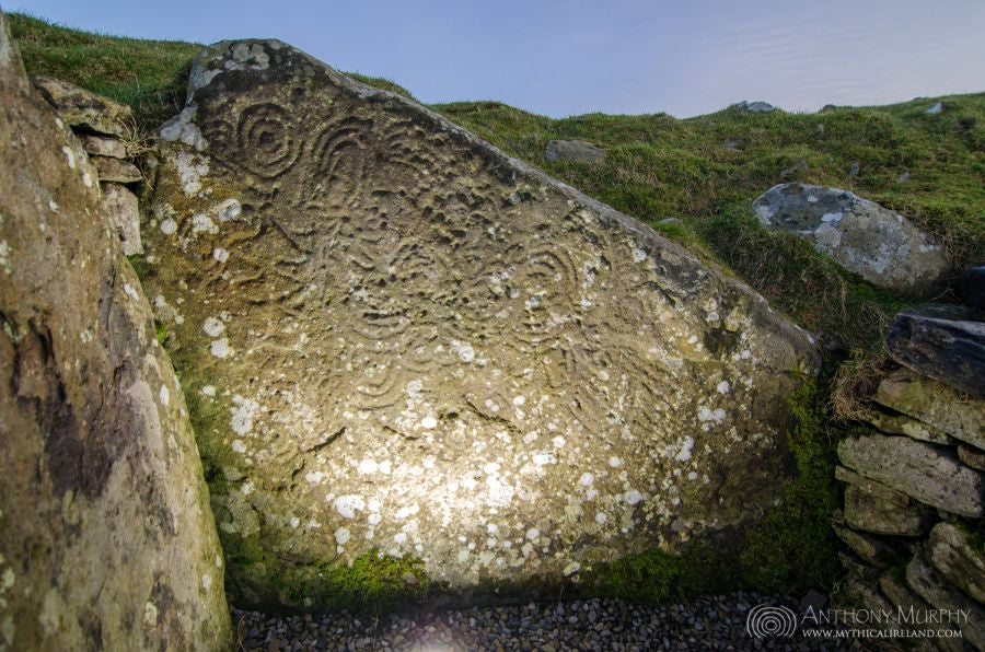
On the right is a zig-zag pattern along the top of stone 14 at Cairn U. Stone 14 is located in the right-hand recess (northern recess) of the chamber. These zigzag patterns may well have been some sort of astronomical counting device. Some theories link the megalithic zigzags with a river, perhaps the Milky Way, the river of the sky. Cairn U is located immediately adjacent to the famous Cairn T. The cairns are lettered, seemingly from west to east. On Carnbane East are Cairns R1, R2, S, T, U, V and W. Click here to see another photo of this zigzag pattern, lit by flash.
Carnbane West
Carnbane West at Loughcrew has a higher concentration of remains than Carnbane East, with a total of two large cairns and ten smaller ones still extant on the summit. However, Carnbane West is less accessible (you have to cross private land to get to it, and you MUST have permission to do so) and the walking time from the road for a fit person is about 20 minutes or so.
The impressive Cairn L is probably the most impressive of the sites atop Carnbane West, probably because it has an astronomical alignment which continues to function to this day. It is unusual in that it features a standing stone inside its chamber, and the layout of the chambered cairn is complex. The cairn at one time had a corbelled dome, which may have risen to about five metres before its destruction in times gone by. There is also a large basin in the large recess.
The cairn has a total of 41 kerbstones, although when Eugene Conwell visited in 1863, he counted 42.
Looking into the passage of Cairn LJean McMann says that if you look out along the passage of this cairn, a hill to the south, once called Carrigbrack (speckled rock) or Sliabh Rua (red hill) is framed in the doorway. The practice of pointing passages towards prominent horizon features is also evident at Cairn T on Carnbane East, which points to the Hill of Slane.
Conwell found 900 pieces of charred bone, 48 human teeth in perfect state of preservation and some round stone balls.
Another impressive site on Carnbane West is Cairn D, which has a circumference of 163 metres. It is the largest cairn in the whole Loughcrew complex, but regrettably suffered considerable damage at the hands of Eugene Conwell who had a dozen labouring men remove the cairn stones in an attempt to find a passage and chamber. After two weeks removing stones during the summer of 1868, he finally gave up, and left Cairn D with a huge crater in the top.
Before Conwell's investigation, he recorded that there were a total of 54 large flagstones. He mentioned that the kerb turned inward at a point facing southeast, about 110 degrees.

Plotting Ireland's ancient buried bounty
One of Ireland’s most noted archaeological landscapes has yielded new secrets to an innovative airborne survey. Using aerial lasers and computer imaging, an Anglo-Irish team has found an even richer concentration of sites than previously known.
A digital surface model at 50cm interval of part of the Summerbank and Ballinvally townlands at Loughcrew.
The Loughcrew Neolithic cemetery, a complex of prominent stone-built mounds enclosing megalithic passage graves, lies on the hilltops of Slieve na Calliagh in western Co Meath, close to Ireland’s watershed between the Shannon and the Boyne. From the cemetery one can see the Wicklow Mountains on the eastern coast and the Mountains of Mourne in Ulster.

Below the hills is “a rich archaeological landscape with a stone circle, henge monument, standing stones and a possible cursus monument”, Colin Shell and Corinne Roughley report in Archaeology Ireland. All are features of the most important British prehistoric complexes such as that around Stonehenge, and emphasise that the Loughcrew region is a “hot spot” in ancient Ireland.
“Although the passage graves themselves, with their megalithic art, are well known and accurately documented, the surrounding landscape has only begun to be considered in detail in recent work,” says the report. This archaeological component of the project is being carried out by Elizabeth Shee Twohig, of University College, Cork, while Dr Shell’s Cambridge team are carrying out the aerial survey.
They are using the recently-developed technology of Lidar (light detecting and ranging), which uses airborne lasers pulsing at 33,000 times a second to scan the landscape and pick up details of relief. “The beam is scanned over the ground in a zigzag manner as the aircraft flies along an accurately planned set of paths,” says Dr Shell. “The flight speed and scan frequency determine the average distance between readings, in our case 60 cm. The red laser is eye-safe, with a spot diameter on the ground of about 25cm.”
Using a base station in Kells of known location and elevation, the team were able to calculate each of the 83 million observations within an area of 5 by 6 kilometres and to within a tolerance of 20cm on the Irish National Grid. The team also obtained conventional aerial photographs to a scale of 1:12,500, which could be used to provide a “digital terrain model”, in essence a computerised view of the landscape that can be viewed from any direction and using any combination of data.
On the broad sweep natural topography, the finer details of the cultural landscape stand out. “By digitally illuminating the surface with a low oblique light, features become clearly visible,” Dr Shell says. “Being able to illuminate the Lidar surface with a digital sun from any direction offers considerably greater flexibility than is available in the real world. We have the best means for revealing the often slight variations in the ground that mark past human activity.
“The Lidar not only provides information on the form and preservation of known sites, but can also reveal potential new sites and define ancient field boundaries underneath the modern ones.”
Some 160km, or 100 miles, of apparent cultural features have been documented, of which only 10 per cent are sites already listed. The new ones cannot be dated from the survey directly, although their form and interrelatedness may provide clues.
Especially dense concentrations of interesting sites have shown up in the lands around Ballinvally and Summerbank, where Dr Twohig has identified what may be a previously unknown henge monument, a banked enclosure of ritual function, and also additional burial mounds close to a known barrow at Drumlerry.
They can also construct “viewsheds”, indicating which parts of the ancient landscape were intervisible: such relationships have proved to be increasingly important in understanding how our ancestors saw their world, and have been utilised by archaeologists from northern Europe on the Maya lowlands of Central America.
The Loughcrew survey has shown serious erosion of the cultural landscape by agricultural improvement in the past forty years, although it has also revealed the survival of parts of sites thought destroyed.
From the Times Online
Videos
A guide to the cairns of Loughcrew using Google Earth with Anthony Murphy:
The cairns of Carnbane, the western hill of the Loughcrew complex, seen from the air. This video features Cairn L, Cairn D and others.
Dawn time lapse at Cairn T (The Hag's Cairn), Slieve na Calliagh, Loughcrew, at Imbolc: