
New LiDAR imagery of Uisneach - annotated with currently known archaeological sites
A new LiDAR survey of the ancient Hill of Uisneach in Co. Westmeath has been undertaken. A press announcement about the survey was released this week, with a single photograph from the new LiDAR imagery.
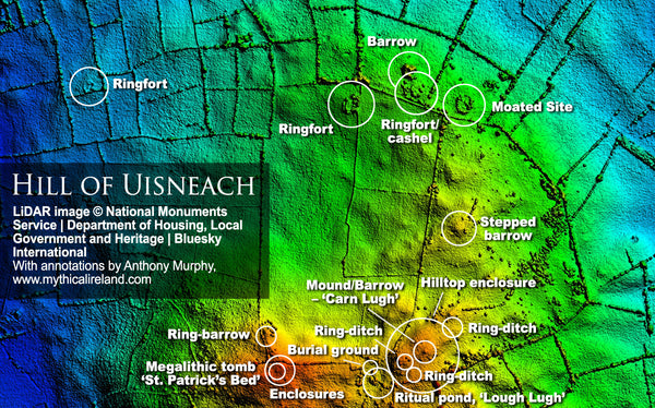
I took the liberty of annotating today's newly-released LiDAR image from the Hill of Uisneach, to show the location of all the known/recorded monuments and archaeological features. As you can see, there's a lot more there than meets the eye! LiDAR (Light Detection And Ranging) produces images of the surface of the earth in minute detail, often revealing denuded monuments or features that are not seen in regular satellite or aerial imagery.
However, only a combination of techniques, including geophysics and aerial/satellite reconnaissance along with the LiDAR, will ultimately reveal everything that's "hidden" from view. Notwithstanding this fact, it is more than likely that the new LiDAR survey will reveal previously hidden or unknown monuments and archaeological features.
The new LiDAR survey was announced on the Westmeath Heritage Facebook page.
Uisneach has been a sacred hill since the Neolithic. The earliest known monument on the hill, St. Patrick's Bed, is in fact a megalithic passage-tomb probably dating to around 5,000 years ago or so.
I am looking forward to seeing more detailed results of this latest LiDAR survey. It should be interesting to see what it reveals!
This survey was funded by National Monuments Service - Archaeology, the Department of Housing, Local Government and Heritage through their Community Monuments Fund and was undertaken by Bluesky International.
The original announcement can be found on the Westmeath Heritage Facebook page.