
The Fennor ringfort: another drone discovery has been officially recorded
Anthony Murphy reports on another archaeological discovery in the Boyne Valley using drone aerial reconaissance.
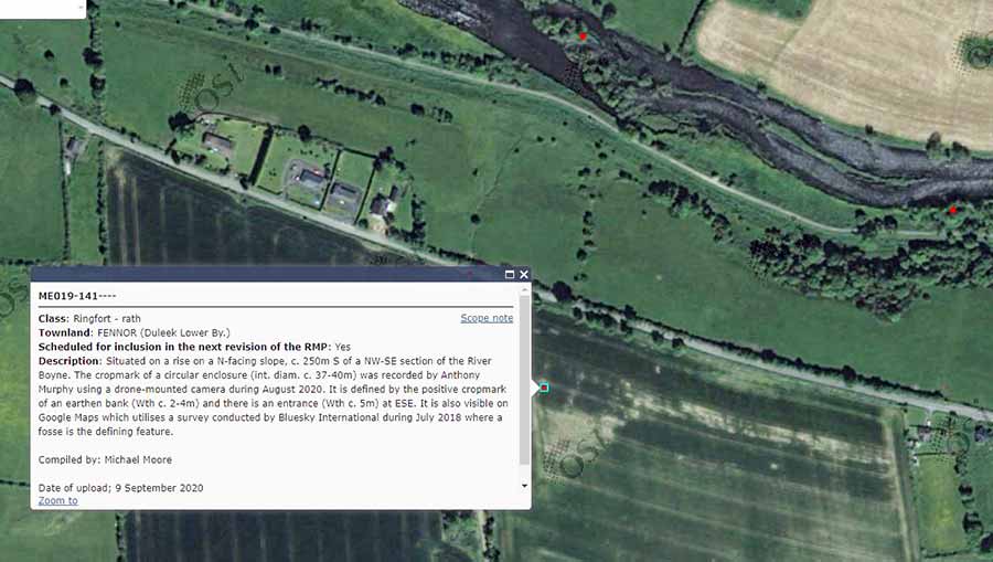
The circular cropmark which I discovered near the River Boyne using my drone just over a month ago has been added to the database of National Monuments.
It has been classified as a ringfort or rath and is located at Fennor, in Duleek Lower Barony, between the Brú na Bóinne archaeological complex and the village of Slane, on the southern side of the Boyne. It is described as follows in the new NMS entry: "Situated on a rise on a N-facing slope, c. 250m S of a NW-SE section of the River Boyne. The cropmark of a circular enclosure (int. diam. c. 37-40m) was recorded by Anthony Murphy using a drone-mounted camera during August 2020. It is defined by the positive cropmark of an earthen bank (Wth c. 2-4m) and there is an entrance (Wth c. 5m) at ESE."

My early estimate at its diameter (c.45m to 50m) was quite close! It is located in a beautiful part of the Boyne Valley, just 3.5km (2.2 miles) west of Newgrange, and occupies high ground overlooking a very beautiful portion of the Boyne Valley between Slane and the Bend of the Boyne / Brú na Bóinne complex. The inhabitants of this ringfort (they are usually dated to c. 600-900AD) would have had beautiful views west along the Boyne towards Slane, and eastwards towards the megalithic complex of Knowth.
I found the ringfort while flying my drone over the Boyne on the August bank holiday weekend. My son Finn was with me at the time. He was also with me on the evening of Tuesday 10th July 2018 when I discovered 'Dronehenge",an enormous late Neolithic henge, close to Newgrange.
See a short video featuring drone footage of the moment of discovery here:
The Fennor rath joins a long list of discoveries, but only a small number of these were made with my drone. The rest were all discovered using Google Earth and Apple Maps, in satellite imagery that had been shot in June and July 2018, at the height of the drought of that year.
My total number of "discoveries" is now at around 300 monuments or possible/likely archaeological features. I'm not sure just how many of them have been officially recorded, but you can browse the online clickable database map at this site: https://webgis.archaeology.ie/historicenvironment/
In addition to Dronehenge, I found other monuments in the Brú na Bóinne World Heritage Site area.
Some of my discoveries will be featured in the forthcoming TV series on RTE 1 television called 'Creedon's Atlas of Ireland'. I spoke on camera with presenter John Creedon at Fairyhouse Racecourse in Co. Meath a few weeks ago about Dronehenge and some of my other discoveries. I'm looking forward to seeing his series, which will be aired some time in October 2020.

In mid-September, I went back out with the drone to have another look at the Fennor ringfort. This time, the scene had changed dramatically. The crop had been harvested, and whatever straw bales left behind had also been picked up. There was no sign at all of the monument, which had been quite vividly visible to my drone just six weeks previously.

I think this neatly demonstrates the time-sensitive nature of archaeological aerial reconnaissance. It is important to fly at the "right times". Ascertaining those times is an interesting challenge! Every crop matures at a different time. Winter crops are generally harvested in July; spring crops in August. The weather conditions play a huge part too. During the spring drought earlier this year, some features became visible in certain crop fields and even in grass, but the winter crops were healthier because there had been sufficient rain in winter to allow them to grow.
If I hadn't flown at Fennor in early August I would never have noticed the ringfort. I was flying at the "right time". The most recent image, from mid-September, reveals absolutely nothing of the monument. It's as if it never existed. But that's not to say it won't become visible again after the field is ploughed. While flying in the vicinity of Giltown (which is located south of the Boyne opposite Dronehenge), I noticed a ringfort in the ploughsoil in a field. I thought that perhaps I had discovered another unknown monument but when I got home and looked on the National Monuments viewer, I saw that it was a recorded ringfort, identified by Tom Condit in 2013.

The fact that it is visible AFTER ploughing is significant. It shows the real difficulty establishing a "right time" to fly the drone looking for archaeology. It seems that, for the foreseeable future, I should be using every available opportunity to launch the drone into our skies. Who knows what is out there, hidden beneath the surface, waiting to be revealed?