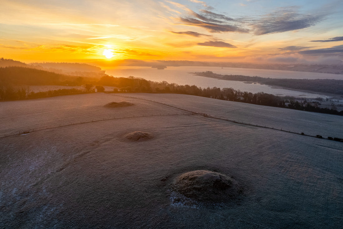
Another possible monument discovered – but this time, in someone else's drone photograph!
It has been an immense pleasure to have discovered a large number of previously unrecorded monuments in the Irish landscape over the past five years, thanks to the use of drone technology and satellite images.
Many of you will know that in the summer of 2018, I discovered a previously unknown late Neolithic henge – dubbed Dronehenge – close to Newgrange in the Brú na Bóinne World Heritage Site monument cluster in the Boyne Valley.
Later, I found several other monuments using my drone, including an early medieval ringfort not far from Knowth. Using Google Earth and Apple Maps, I found a huge trove of previously unknown or unrecorded monuments of varying sizes and ages, and to be honest I don't have an official count but it may be several hundred.
Recently, however, I found what looks like a Bronze Age ring barrow in County Westmeath in a drone photograph. The catch? The photograph was not taken by me. It was shared by well-known drone photographer Peter Nagy on his DRONE Photography Ireland Facebook page. It shows a series of Bronze Age barrows in a cluster close to Lough Lene in Westmeath, between the villages of Castlepollard and Fore. Here's what the mounds look like in Google Earth:

My immediate reaction upon seeing Peter's drone photo was to go to the Historic Environment Viewer on the National Monuments Service website to see what was recorded there. One detail jumped out at me. A very subtle ring in the grass beside the largest of the barrows was NOT recorded in the Sites and Monuments Record (SMR) on the website. Recorded monuments are indicated with a red dot. Here's Peter's image with the ring circled:

I quickly made contact with Peter Nagy, asking him to phone me because I felt there might be something significant in his image. (It is a gorgeous photograph by the way, and I highly recommend following Peter's DRONE Photography Ireland page for more sumptuous images of the Irish landscape). We had a chat on the phone and Peter agreed with my suggestion that I email the photo to the National Monuments Service to see if their archaeologists agreed that this might be an unrecorded monument.
The barrow mounds are located in the townland of Lakill and Moortown, close to Lough Lene in Westmeath. I emailed the photo and details to Caimin O'Brien, who looks after the Westmeath entries in the SMR.

I'm delighted to report that the HEV has been updated with details of our "potential" find. I say potential because there is a possibility, as pointed out by Caimin O'Brien, that the ring barrow in our photograph is the one numbered WM007-016---- in the HEV, and that the red dot was incorrectly positioned when it was recorded.
A further aerial photography survey of the complex is needed to help verify whether this is in fact a new discovery. The best time for this drone survey would appear to be at dawn, when the sun is low in the sky and when the low angle of its light would highlight any low-profile monuments or features in the fields overlooking Lough Lene.
I look forward to seeing more of Peter's images of the area. And who knows – maybe we will find another hidden monument or two?

1 comment
Congratulations, Anthony! Is there any photo in your own drone of the small barrow at Oldbridge overlooking river?